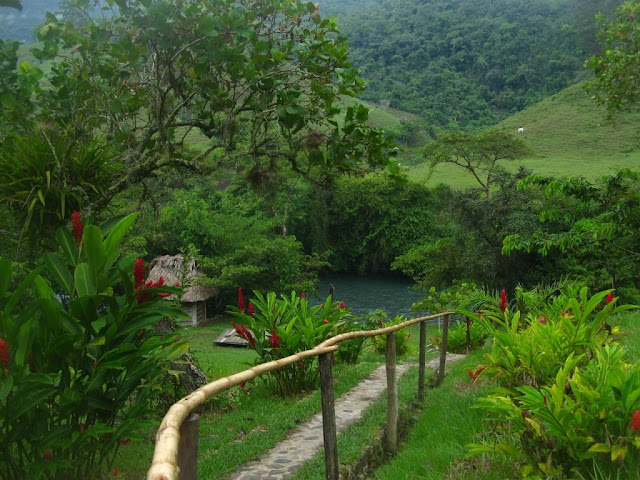
It seems like Central America has some of the wettest areas and driest areas in the world. The vegetation is remarkly variable as a result.
Tuesday, April 20, 2010
Beaches
Its been a few 2 months since I updated here. Sorry for the absence, its partially because I´ve had more to do when working and partially due to time in Canada. In the next week or so I am planning to add quite a few fotos and catch up on Costa Rica and Nicaragua. I´m back in Honduras right now for 2 or 3 months (probably 3 as there are classes to teach in June and Honduras is in the World Cup (soccer) for the first time in 28 years, so June looks to be very interesting here!). I plan to travel quite a bit in the time, as well as working in Tegucigalpa.
---------------------------------------------------------------------------------
So far I have only made it to the Pacific coasts of the countries I´ve visited in Central America. The Pacific beaches are rockier with bigger waves and don´t have the bright blue calms waters of the Carribean.
Costa Rica coastline
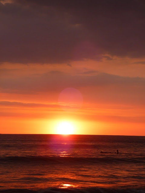
Sunsets along the Costa Rica coastline
Sunsets along the Costa Rica coastline
Pure gold sunset along the Costa Rica coastline
And the last sunlight of 2009 for CostaRica:
In Nicaragua, most of the beaches have very few people and amazing areas to walk and explore.
The tides pools at this beach area in Nicaragua were full of an amazing array of sea life and we spent a lot of time exploring.
Wednesday, January 13, 2010
Managua - as U2 said ¨where the streets have no names¨
Here is the house I live in, from the street.
I live in a middle class neightbourhood/house with a middle class family. The wealth distribution is very skewed in all of central america, with a very small population of very rich (from old money), a very small population of middle class, a large population of lower middle class, and a very large population of very poor.
From behind the front wall, here is the front of the house and looking through from the front towards the back. The house is surrounded by a large patio/coutyard with a number of sitting areas and small gardens.
This is my room
And the living room looking through to the backyard. As you can see the house is somewhat open to the outside.
And a close of the security wires and broken bottles common at the tops of the walls in most neighbourhoods (common to all but the poorest).
This is the only picture I have right now of the slums. These are the worst areas of Managua and are just areas of squatters.
Almost all the streets in Managua (except for probably 8 major streets) have no names. This make maps not very useful and navigation only possible if you sort of know where you are going before you go. My address is "por la Universidad Evangelical de Nicaragua, 2 cuadras al sur (south), 3.5 cuadras arriba (up, which means east)" or "de donde fue la casa de Meija Godoy (where the house of Meija Godoy used to be), 2 cuadras abajo (down, west), 1.5 cuardas al lago (towards the lake)". The father in my house is fond of saying Managua is the largest village in the World.
Although Managua is the capital city, there is very little of tourist interest to see here. The city experienced a large earthquake in 1972 (1 day before Christmas) and almost all the city center was destroyed and not rebuilt. For this reason, there are very few buildings taller than 1 storey and the city is very spread out. I have heard that what happened in Haiti yesterday (January 12) is likel very reminiscent of the destruction here.
This is the view from the highest point in central Managua , the Loma de Tiscapa (a hill beside a volcanic laguna) looking north including Lake Managua. The tall building is a hotel and I think the only tall building survive the earthquake.
Looks south from the Loma across the Laguna de Tiscapa, the rest of Managua is visible. There are an amazing amount of trees here and the city is basically hidden in them. I live close to the tall blue building visible on the horizon, about 1/4 of the way in from the left side of the photo (and in the lower photo). In the lower photo, the new catherdral is visible(looking moorish or boobish) and the mall closest to my house (with red lettering). Where the hills are in the distance, through the clouds in this photo, is Volcan Masaya, the closest volcano (about 20 km) which is active and continues to emit dust and smoke.
On the Loma is a large statue of Sandino that can be seen from almost everywhere in the city:
The old cathedral also survived somewhat and stills stands, although is unsafe for people to enter.
Sunday, December 13, 2009
Sounds of Managua
So far this blog has been about images, I seem to be able to express my experiences best with photos, not with words. One possible culpruit of this is years of technical writing, stripped of all extranious words, colour, and emotion.
But, my camera has been injured, possibily mortally. I'm waiting for a response from a friend's brother about the possibility of repairs, one bonus of this happening in a third world country, but I fear it will be too expensive. (Oops....no Canon camera parts in Nicaragua).
So, this entry will have no photos. Instead, I've tried to catelogue all the sounds I hear on a daily basis. The extent and types of noises are one of the major differences here that constantly remind me I'm not in Canada (as well as the smells, but I'll spare you those).
Street vendors wandering the streets, calling out their wares for sale.
Horse hoofs and wooden wheels (on the horse drawn carts that still move people and stuff even in the capital)
Animals
Guys:
But, my camera has been injured, possibily mortally. I'm waiting for a response from a friend's brother about the possibility of repairs, one bonus of this happening in a third world country, but I fear it will be too expensive. (Oops....no Canon camera parts in Nicaragua).
So, this entry will have no photos. Instead, I've tried to catelogue all the sounds I hear on a daily basis. The extent and types of noises are one of the major differences here that constantly remind me I'm not in Canada (as well as the smells, but I'll spare you those).
Street vendors wandering the streets, calling out their wares for sale.
- La Presa (newspaper)
- Milk
- sour milk
- bananas
- avocados
- many, many things I can't understand
Horse hoofs and wooden wheels (on the horse drawn carts that still move people and stuff even in the capital)
Animals
- many types of wild birds
- pet parrots,
- dogs, dogs, and dogs
- chickens
- rosters
- sometimes cows
- bats in the roof
- cats on the tin roof
Guys:
- whistling
- sssing
- blowing kisses
- calling 'mi amor´, adios, hola, buenas
- ooh
- hermosa or bonita (words for pretty)
- linda or barbara (slang words for beautiful)
- chela (ie something like whitey), chelita
- honking from vehicles.
Thursday, November 26, 2009
Alta Verapaz
This post has been a hard one to write. Generally photographs don´t capture real feeling of a place and for me, this is likely never been more true than for my time in the Lanquin area of Guatemala. Partially this is because I couldn´t have my camera with me, but for lots many other reasons too. Hopefully I will get some pictures from other people that had water proof cameras. But even with the inadequecies of photos I think this post is worth it.
Lanquin is a small little village about 6 hours from Guatemala City and Semuc Champey another 25 minutes in the back of a pickup truck. There are not a lot of travellers there at all, but the ones who make the trip all come to see the Grutas de Maria and Semuc Champey. This area is all about water - perfect for me.
The hostel I stayed in was in a gorgeous area, with green sloping grass and tropical plants down to a blue river for swimming. The each little cabin was on a platform and was constructed with wood and palm leaf roofs.
This part of Guatemala is limestone and has a lot of karst features. The Grutas de Maria is a cave system that you tour with a guide. It is partially full of water, so there is lots of swimming, climbing up waterfalls, and jumping down 10 feet off rocks - all inside of a cave with either a headlamp if you were smart enough to bring one, or a candle supplied by the guides. I don't have any pictures from inside the cave, as my camera is not waterproof. I am hoping that I will get some by email from some other travellers.
After the caves, I visited Semuc Champey. This is an area where the Lanquin river flows underground for about 300 m, exiting in over a waterfall. We climbed up inside the waterfall and jumped in to the pools beneath. Above the area where the river flows underground is a relatively flat section of limestone, filled with small, turquiose and green pools of water, each cascading down to the next in a small waterfall. The view from the Mirador, complete with howling howler monkeys is fanciful and swimming in the pool feels otherworldly. If you closed your eyes and pictured the perfect jungle paradise of rivers, waterfalls, trees, animals, this is it. And there were only 15 people in the whole area all day.

Hiking at Semuc Champey
View of Semuc Champey from the Mirador
The area where the river goes underground and the start of the pools on the left.
Close up of the pools
Thursday, November 5, 2009
Working in Nicaragua - Chureca

In my second week in Nicaragua we spent 5 days installing piezometers and sampling at Chureca, Managua's city garbage dump. Apparently the dump was started in its current location after the earthquake that decimated Managua in 1972; they needed a large area, close by for all the building debris, and the large vacant area adjacent to the lake was selected. But, I think it has continued as the dump for all the city waste since then and now is very large and slumping into the lake. The garbage is about 20 m high.
This is not a landfill, it is a dump: there is no lining, no leachate collection, no control on what comes in, and no planning on where different materials are placed. In the image below, the large grey area along the top is Lake Managua, the dump is visible just south, with a long road running through it.
The green areas between the dump and Lake Managua are areas where vegetation is growing on older portions of the dump; the garbage extends right to the edge of the lake. When the lake level is high, it is above the bottom of the garbage.
Life in the dump
There is a village in the dump.
People work in the garbage and live immediately adjacent, or on top, of the garbage. Each truck that comes in to the dump has a handful on adults and children inside it, digging through for the best stuff, before it even gets dumped.
One thing that struck me about the houses was that even in a village in a dump, there are those that are better off, and those that aren't. Some house have fences, more permanent walls made of scrap sheet metal, some are even painted. Others have plastic sheeting roofs and cardboard walls.

(film crew was with us, documenting the Chureca and the work being done there for Spanish TV)
And animals - everything you could imagine lives and grazes here - cows, horses, goats, cats, dogs, I'm sure rats, and vultures.
Even still, there were some beautiful areas, if you could ignore the smell and forget what was behind you.
Field Work
For the people who read this that have an environmental background, I wanted to capture some of the differences in field work here compared to what we are used to. One of the big differences from consulting is that here people time is pretty much the cheapest item, I think. We had 10 people in the field (6 labours to dig holes) and only one waterra valve: there was a lot of standing around and I had to turn off my project management thoughts.
Drilling methods - for shallow wells anyway - and drill cutting (note the shoe)
Vegetation clearing - and protection
Driven piezometers in the lake bed
Subscribe to:
Comments (Atom)


